Executive Summary
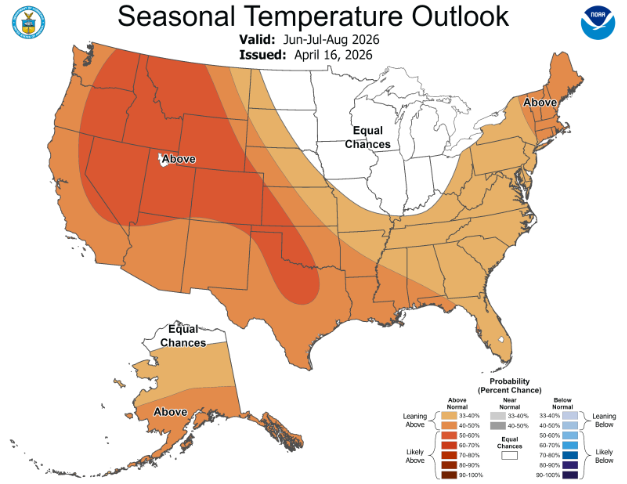
Summer 2026 is shaping up to be one for the record books. A strengthening El Niño is the dominant force shaping weather expectations across every corner of the United States this season. While the full force of this ENSO cycle is not expected to materialize until well into summer or early fall, its fingerprints are already visible in early heat records, persistent drought conditions, and volatile weather.
Critically, this is not a pattern that will fade with the leaves. El Niño is expected to linger through the fall and into winter due to its expected summer strength. From ERCOT to ISONE, every ISO is facing its own version of the same challenge: more heat, more load, more uncertainty, and a generation stack that is evolving faster than ever. Here is what to expect for each U.S. grid.
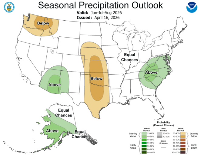
CAISO/WEIM: An Already Severe Drought is Likely to Worsen
California, the Desert Southwest, and the Pacific Northwest are quite literally in the hot seat this summer. Expectations are consistent across forecasts: the Pacific Northwest will experience hotter and drier conditions than normal for the majority of the summer, with a potentially strong start given a warmer-than-normal June as we phase into the strong El Niño.
The Sierra Nevada Mountains and the Rockies are currently experiencing widespread drought, with some areas already classified as Exceptional Drought. This follows a well-below-average winter, with snowpack either completely melted or sitting below 50% snow water equivalent across much of the Pacific Northwest, and we have not even reached the start of summer.
The implications are significant: shifting water supplies throughout the season, competition over water resources, very little hydro generation, and extreme wildfire risk across most of the region, with little relief expected.
The implications are significant: shifting water supplies throughout the season, competition over water resources, very little hydro generation, and extreme wildfire risk across most of the region, with little relief expected.
One additional factor worth monitoring is tropical activity in the Pacific Ocean. While El Niño suppresses Atlantic hurricane development, it has the opposite effect in the Pacific, where rapidly warming ocean waters are creating favorable conditions for storm development. Increased tropical activity can be expected in the Pacific this summer, which introduces some risk to the Southern California region. Tropical storms have made landfall in Southern California before, and it would not be surprising to see that threat materialize again this year.
Tropical storms have made landfall in Southern California before, and it would not be surprising to see that threat materialize again this year.
Fortunately, the generation stack out west has grown considerably in the renewable and battery sectors. As of April 1, 2026, CAISO has 16 GW of battery capacity installed, 22.5 GW of solar, and 8.6 GW of wind on the grid. Compared to July 2025, that represents a 3 GW increase in battery storage and roughly 1 GW of additional solar.
More capacity is expected to join the stack this summer, with the most significant addition being SunZia Wind South and North, combining for 3.6 GW of wind generation in New Mexico that will be integrated into the CAISO generation stack starting in June.
CAISO recently broke its all-time wind generation record, surpassing 7 GW for the first time, suggesting portions of SunZia are already coming online. Once fully operational, SunZia will be the largest wind farm in the Western Hemisphere. This addition will help relieve evening peak grid stress, particularly on windy days—and will likely introduce new congestion patterns for a region that is already heavily renewable-weighted in the SP15 zone.
This addition will help relieve evening peak grid stress, particularly on windy days—and will likely introduce new congestion patterns for a region that is already heavily renewable-weighted in the SP15 zone.
ERCOT: A Three-Way Race Between Solar, Drought, & Large Loads
ERCOT is in for an exciting summer, as El Niño-driven drought and heat will be in a race with planned generation additions. The region is already in a harsh drought, and conditions are not expected to improve meaningfully throughout the summer. Wildfire warnings should be taken seriously, especially on very windy days.
When rain does arrive, it will likely come in force as El Niño surges additional moisture into the atmosphere, increasing weather volatility and producing more extreme storm events. While these storms may help ease the drought, the extremely dry ground will make flash flooding a real concern throughout the season.
Click here to continue reading the summer grid outlook for ERCOT and other US ISOs.

.svg)


%20(3).png)
%20(2).png)
%20(1).png)


.png)


.avif)


.avif)

.avif)

.avif)

.avif)
%20(15).avif)
.avif)
%20(10).avif)

.avif)

.avif)
.avif)


.avif)