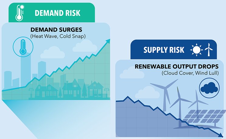
A major heat wave is headed for PJM, and it's shaping up to be one for the books. Early next week, temperatures are expected to soar into the 90s across nearly the entire region. This isn’t your usual patchy summer heat; it’s a widespread, system-wide event. The culprit? Upper-level ridging that’s blocking cooler air and precipitation, trapping hot, humid air under clear skies and allowing surface temperatures to skyrocket.
Typically, PJM’s large geographic footprint means not every subregion experiences the same weather at the same time. But next week, the entire ISO, from the Midwest to the Mid-Atlantic, will be sweating it out. That kind of uniform heat sets the stage for serious demand peaks.
Forecast Watch: PJM Already Set to Exceed Summer Expectations
PJM forecasted 154 GW for this summer’s peak. As of now (still a week out) they’re already calling for 155 GW. That’s higher than their own seasonal forecast and well above last year’s peak of 152.7 GW (set on July 16). And let’s be clear: it’s still June. PJM hasn't seen summer demand peak in June since 2014.
At Amperon, we are currently forecasting demand to be higher than what PJM is currently forecasting, which would make this the highest demand PJM has seen in years. If that holds, we’re talking about overshooting PJM’s summer prediction of 154 GW— and the season’s just getting started.
We’ve all been hearing about exponential load growth in PJM. Well, the moment has arrived with a bang. In today’s grid, misses like this matter. Amperon’s models are built for this kind of volatility — and we’re getting it right.
The plot below shows temperature vs load actuals for PJM over the last few calendar years, with last year’s summer peak highlighted. You can see that 2024 load peaks exceeded 2023 and 2022 peaks at the same temperatures anywhere from 2-6 GW. You can also see last winter had higher loads than the winter before at the same temperatures. That doesn’t always translate to summer, but it’s a bit more evidence that load growth and high temperatures is likely to break the summer load record. The current weather forecast has temperatures consistently over 92 degrees for at least five hours prior to the demand peak across the ISO. To us, it makes sense that we’ll exceed 2024 demand, if these temperatures materialize. But of course, a lot could change in the next few days, and our forecasts will update accordingly.

Why the Forecast Is So High: Supporting Factors
Let’s break down what’s contributing to this surge in demand:
- School schedules: While Chicago and Pennsylvania schools are already out, New Jersey schools are still in session, driving up daytime demand.
- Temps will be hotter and more widespread than 2024:
- Chicago (ComEd): Hit 85°F on last year’s peak day. This time around? Forecasting 93°F.
- Newark (PSEG): 99°F last year, now projected for 98°F and 99°F on Monday and Tuesday, with even hotter feels like temps.
- Philadelphia (PECO): Saw 98°F last year; now eyeing 97–101°F Monday-Wednesday alone.
- Pittsburg saw a max temperature of 93 degrees last year; now forecasting 98 Monday and 101 at least on Tuesday.
- Baltimore (BGE): Reached 104°F in July 2024. This year? Already forecasting 98°F+ with a hotter Tuesday and Wednesday ahead as well as hotter heat indexes.
Even a 1–2°F difference matters significantly when spread across an entire ISO. Add with continued load growth, and you've got the recipe for new records.
Weather Forecast as of 6/18/25

Heat Builds Over Time — And So Does Grid Stress
This isn’t a one-day spike. The heat begins building this weekend and continues through early next week. With minimal precipitation and strong high pressure in place, the grid will feel the stress of sustained elevated temperatures.
Late Tuesday, June 24th and Wednesday, June 25th may bring a chance of some relief in the western portions of PJM with possible precipitation, but by then, the demand damage may already be done.
Capacity and the Bigger Picture
According to PJM’s Summer 2025 Outlook, the system’s expected capacity is 179.2 GW (plus demand response). If demand hits higher than 155 GW in June, how did they miss the summer peak forecast by this much already?
This heat wave is likely just the first major test of the season. If temperatures climb even higher in July or August, are we on track to exceed even 160 GW? At what point does demand get uncomfortably close to capacity. Heat Alerts will start to be sent out by PJM soon enough. Additionally, there is a chance we could see some Maximum Generation Emergency and Load Management Alerts, especially on the 24th when wind generation is currently expected to be on the weaker end during the solar ramp down.
Final Thoughts
To PJM: We haven’t even made it out of June, and we’re already knocking on the door of 160 GW – which is far higher than the predicted seasonal peak. That's a pretty big miss for such a critical forecast.
For the rest of us: Buckle up as we see temperatures start to rise and prices become more volatile. Amperon’s demand forecast updates every 30 minutes, giving you real-time clarity in volatile conditions like this. Keep an eye out as this story continues to develop; summer is just getting started.

.svg)


%20(3).png)
%20(2).png)
%20(1).png)


.png)


.avif)


.avif)

.avif)

.avif)

.avif)
%20(15).avif)
.avif)
%20(10).avif)

.avif)

.avif)
.avif)


.avif)