It appears our friend Punx Phil may have been hitting the meteorology textbooks this year because spring seems to be making an early appearance for a significant portion of the country – at least for now. According to the Climate Prediction Center, regions east of the Rockies are in for warmer-than-normal temperatures over the next two weeks, while the West could experience more chilly, rainy, and gloomy atmospheric river conditions. Let's take a closer look by region.


While this is only the next two weeks, it is undeniably a spring preview, particularly for ISONE and NYISO where snow can linger as late as April or May. For the Midwest and PJM, this is hope that spring will stick around, marking the start of what we refer to as Shoulder Season.
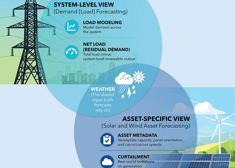
But what is Shoulder Season? You may have heard of it as a way to save on travel when planning your vacation. In general terms, it is the period of time between a peak season and off-season. In energy terms, it is the transitional period during spring and fall when demand is low due to mild temperatures, and renewable generation can be robust. Picture those blissful days when you get to throw open your windows and finally unearth your short-sleeved shirts. Demand tends to be lower on days like these, especially when the sun is shining or it’s the weekend.
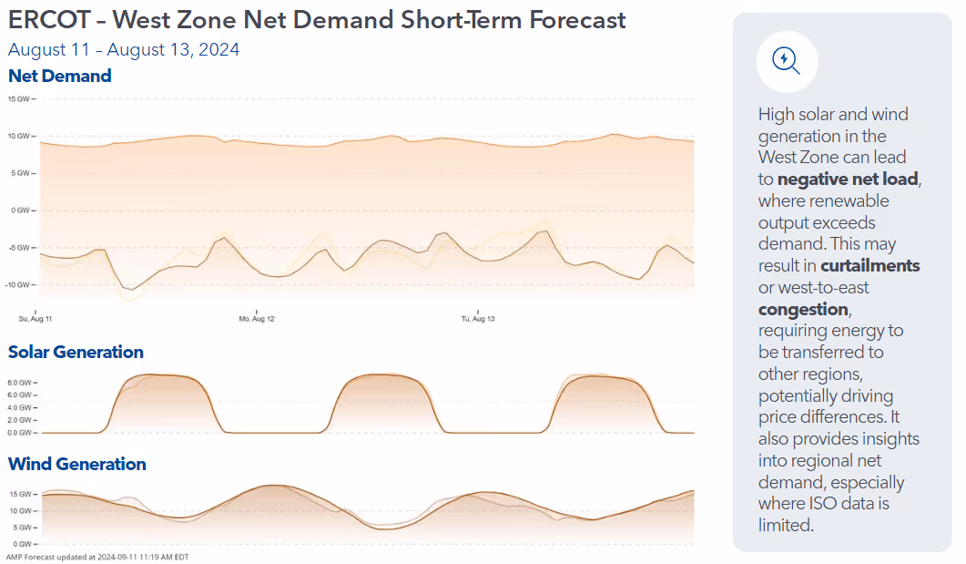
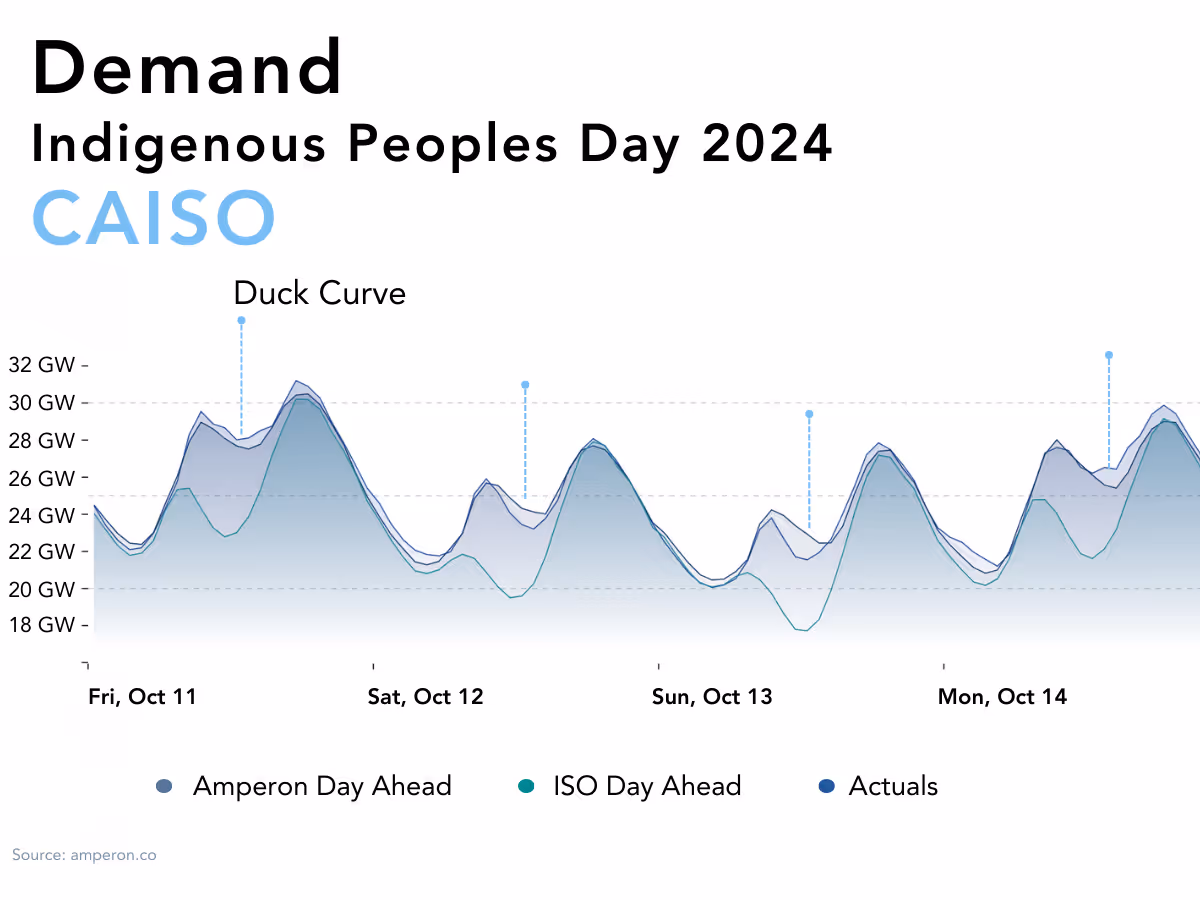
A buzzword that is thrown around during Shoulder Season is “Curtailment.” This occurs when there's an excess of Variable Energy Resources (VER) like wind and solar power, but not enough demand to absorb the surplus. This gives us the option to store this excess energy for peak demand periods, or curtail it, meaning to temporarily shut off wind turbines or solar panels. These kinds of days are when we typically see subdued energy prices, making spring a somewhat uneventful period for us energy people. This is commonly seen in CAISO, where the region has a surplus of renewables, with approximately 18,517 MW of solar and about 8,358 MW of wind capacity, according to the January 2024 Key Statistics Report.
Meanwhile, California has been grappling with, what we Northeasterners like to call, a Winter Depression thanks to a Pineapple Express of Atmospheric River events that have flooded the region in recent months. Rainfall and below-average temperatures have become the norm for much of CAISO. The first weekend of February witnessed a surplus of rain across the region, especially in Southern California, making this February the fourth wettest on record for Downtown Los Angeles, with a total of 12.56 inches so far this month, which is 88% above the average seasonal rainfall.
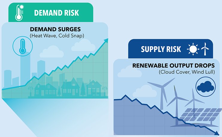
These atmospheric river conditions can translate to heightened grid load, whether from increasing lighting load or even heating degree days due to cooler air swapping in. Additionally, these conditions can drive up net demand due to reduced solar generation caused by cloud cover accompanying these storms. Evening ramps tend to be particularly volatile due to the weaning off in solar generation and the possibility of wind fluctuations during the diurnal wind variations. Batteries are a solution during this volatile time, especially during Shoulder Season when net demand can be minimal during the day. Over the past year, CAISO’s installed battery capacity has increased by 2,746 MW according to their January 2023 and 2024 Key Statistics documents. As this number continues to grow, this will only come to benefit the ISO in volatile periods in the years ahead, especially as the weather becomes more extreme.
While Punxsutawney Phil’s predictions may have been accurate this year, it doesn’t mean he always will be in the future. Stay ahead of the game by consulting Amperon’s demand and net demand forecasts to prepare for the upcoming scorching summer. Don’t forget to subscribe to chat with our trusted PHD Meteorologist, Dr. Mark Shipham for expert insights, that are guaranteed to be much more in-depth than just looking for a shadow.

.svg)


%20(3).png)
%20(2).png)
%20(1).png)


.png)


.avif)


.avif)

.avif)

.avif)
.avif)
%20(15).avif)
.avif)
%20(10).avif)

.avif)

.avif)
.avif)


.avif)